
Description
Xiangkhouang (Xiengkhouang) (Lao: ຊຽງຂວາງ, meaning "Horizontal City") is a province of Laos, located in the Xiangkhouang Plateau, north-east of the country. Originally known as Muang Phouan, the present capital of the province is Phonsavan. The population of the province as of March 2005 census is 229,521.
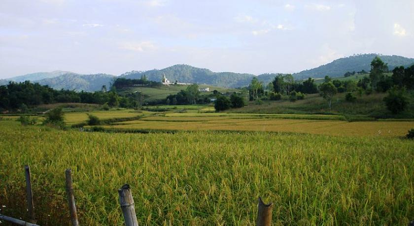
Xiangkhouang Province covers an area of 15,880 square kilometers (6,130 sq mi) and has a largely mountainous topography. The province borders Luang Prabang Province to the northwest, Houaphan Province to the northeast, Vietnam to the east, Bolikhamsai Province to the southeast, and Vientiane Province to the southwest. Apart from floodplains, the largest area of level land in the country is located in the province's Xiangkhouang Plateau. This area is characterized by rolling hills and grassland whose altitude averages 4,250 feet (1,300 m). The country's highest peak, Phou Bia (9,252 feet (2,820 m)), rises at the southern side of the plateau. Nam Et-Phou Louey is a National Biodiversity Conservation Area (NBCA) in the province which covers a total area of 5,959 km2 and overlaps into Houaphan and Luang Prabang provinces.
Xiangkhouang Province is one of the main maize producing areas of Laos. It was heavily bombed during the Vietnam War era. The Plain of Jars site has been proposed for listing as a UNESCO World Heritage Monument.
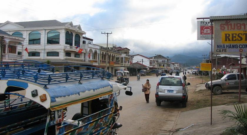
Phonsavanh is the provincial capital of Xieng Khouang province. It was built in the late 1970s and the old Xieng Khouang which had been destroyed during the Second Indochina War. It is located in the centre of the Plain of Jars and has a pleasant climate all year around, although it can become pretty cold during winter nights (it is on an altitude of 1100m). As soon as you leave town the countryside is dominated by green hills and pine forests. Villages consist of colourful wood houses and often raise cattle. You will see more than one Hmong cowboy with brown and violet cowboy hats. During Hmong New Year there are even bullfights in Phonsavanh.
History
While the origin of the Plain of Jars' people is unknown, the recorded history of Xieng Khouang is interlinked with the Tai Phuan. As an ancient civilization, its prehistory is linked to the enigmatic megalithic stone jars of the Plain of Jars (with prehistoric material recorded to the period of even 2000 BC, with Iron Age period of 500 BC and 500–800 AD period dominating the archaeological finds) representing burial grounds of ritualistic practices with extended history spread from Angkor period to the Hindu and Buddhist religious impacts. The Tai Phuan or Phuan people are a Buddhist Tai-Lao ethnic group that migrated to Laos from southern China and by the 13th century had formed the independent principality Muang Phuan at the Plain of Jars with Xieng Khouang (the contemporary Muang Khoun) as the capital. They prospered from the overland trade in metals and forest products with India and China. In the mid-14th century, Muang Phuan was incorporated into the Lan Xang Kingdom under King Fa Ngum.
The Xieng Khouang Plateau has been surmised, based on archaeological finds of Bronze and Iron Age of the period between 500 BC and 500 AD, as the center of trade representing a large area of upland Southeast Asia covering Vietnam, Samrong Sen in Cambodia, and the Khorat Plateau in northeast Thailand, Danang City in Laos, and the North Cachar Hills of northeastern India.
According to the Pongsawadan Meuang Puan or the Muang Puan Chronicles, the Tai Puan, a Buddhist Tai-Lao ethnic group, are said to be the first people who migrated in the 13th century from China and settled in this province; they had established trade in metals and forest produce and consequently were prosperous. During the mid 14th century they were subsumed into the Lan Xang Kingdom. The Siamese wars in the 18th and 19th centuries resulted in the Tai Puans' loss of freedom.
In subsequent years the Haw invaders from China ravaged the province and also Luang Prabang by looting. During the Franco-Siamese treaties in the 1890s it came under French colonial rule under The Treaty of French Indochina, which extended to a short period beyond World War II. During the Second Indochina War of the 1960s and 70s there was more suffering to the people of the province due to the Laotian Civil War between the Royalist and the Pathet Lao until 1975 when the Pathet Lao took power. Xiangkhouang was the province most bombed by the USAF airplanes in support of the Royalist forces. As a result of this extended war, Muong Khoun, the original capital of the province suffered much damage due to bombing by the USAF and resulted in shifting of the capital to Phonsavanh. During this war, most of the temples built in the period from the 16th and 19th century were destroyed except for the Vat Pia Vat temple. The royalist were led by General Vang Pao, who was born in the province, during the war in the 1960s.
Geography
Xiangkhouang Province covers an area of 15,880 square kilometers (6,130 sq mi) and has largely a mountainous topography. The province borders Luang Prabang Province to the northwest, Houaphan Province to the northeast, Vietnam to the east, Bolikhamsai Province to the southeast, and Vientiane Province to the southwest. The capital is Phonsavan. Xiangkhouang and Vientiane Provinces are part of the Nam Ngum watershed.
Apart from floodplains, the largest area of level land in the country is located in the province's Xiangkhouang Plateau. This area is characterized by rolling hills and grassland whose altitude averages 4,250 feet (1,300 m). The country's highest peak, Phou Bia (9,252 feet (2,820 m)), rises at the southern side of the plateau, while the Plain of Jars is in the plateau's center.
The province is 400 km northeast of Vientiane. Phu Bia at 2700 m elevation is the highest peak in the province, and also the highest in Laos. The capital city is at an elevation of 1,000 m.s.l with Kham district situated in a low-laying basin at an elevation of 600 m.s.l.
Protected areas
Nam Et-Phou Louey is the National Biodiversity Conservation Area (NBCA) which covers a total area of 5,959 km2 extends within the Xiangkhouang Province apart from the Houaphan, Luang Prabang provinces. The park consists mainly of mountains and hills, with altitude ranging between 336 and 2257 metres above sea level. The area is the source of many rivers. It is named after the Nam Et River and Phou Louey Mountain (“Forever Mountain”).
The area has a high level of biodiversity, and a number of endangered species including tiger, leopard, clouded leopard, Asian golden cat, marbled cat, civet, gaur, Sambar deer, white-cheeked gibbon, sun bear, black bear, Asian elephant, dhole, hornbill and three species of otter.
Demographics
Phonsavanh is home to various ethnic groups, such as the Phuan, whose ancestors once founded the kingdom of the same name, the Hmong, whose New Year’s celebrations in Xieng Khouang are famous throughout Laos, and the Khmu and Tai Dam. There is also a minority of Laotian Chinese and Vietnamese as well as some international workers and missionaries from Korea and the USA. The population of the province as of March 2005 census is 229,521.
Economy
Xiangkhouang Province is one of the main maize producing areas of Laos. The main centre for trade and tourism is Phonsavan. The main economic activity in Phonsavanh is based on government administration, mining companies from China and Australia, tourism and the work of NGOs related to UXO clearance.
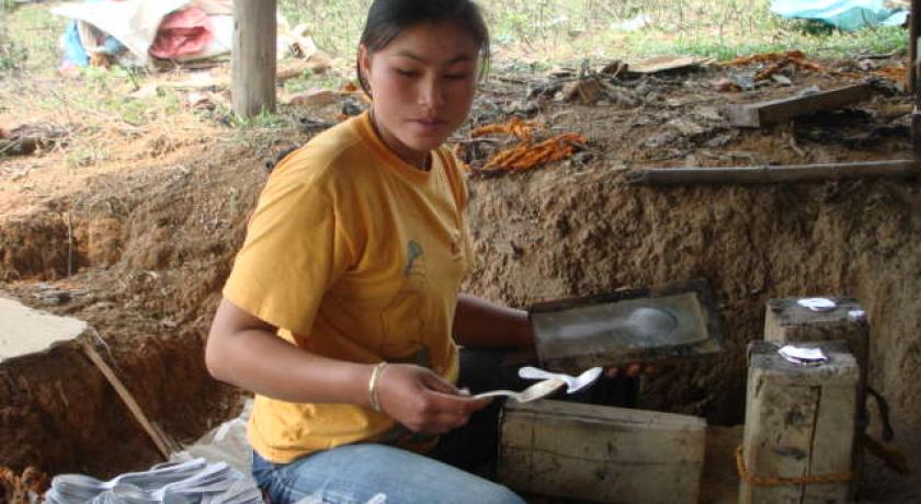
In the village of Ban Napia near Phonsavan, villagers re-use UXO scrap metal to make spoons to be sold as souvenirs. The war scrap metal is checked for safety beforehand by UXO Lao. This community based project provides valuable income for the villagers. As of 2012, 3 minor accidents involving the UXO metal had been reported.
Landmarks & Attractions
There are many notable landmarks in the province. The tourism department of Laos has listed 63 sites of which 32 are natural sites, 18 are cultural sites, and are 13 historical sites. Of these some of the important sites are the following.
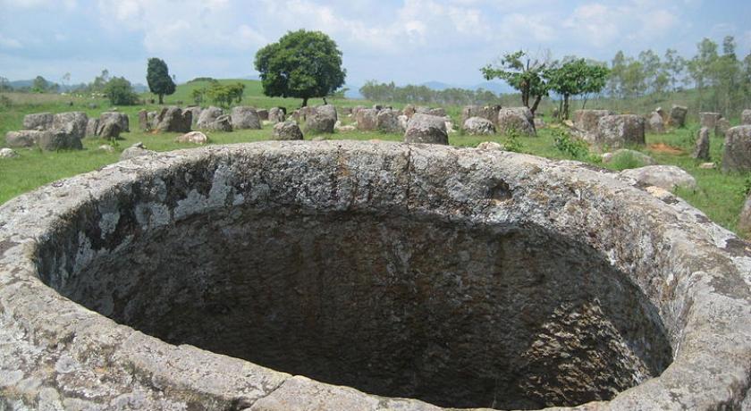
The most prominent and popular sites are Plain of Jars which consist of urns of large stone of height varying from 1–3 metres (3 ft 3 in–9 ft 10 in). They are found throughout the province at many locations in bunches of 300 jars at each location. Archaeological studies have been carried out at many sites, which indicate that these were funerary sites of Bronze and Iron Age (2,000 to 2,500 years old) period megaliths. The nearest location of these urns from Phonsavanh is the Jar Site 1, with an area of 25 ha. The largest jar found here is of size 2.5m x 2.5m, while the rest are half this size. One jar has decorations on it.
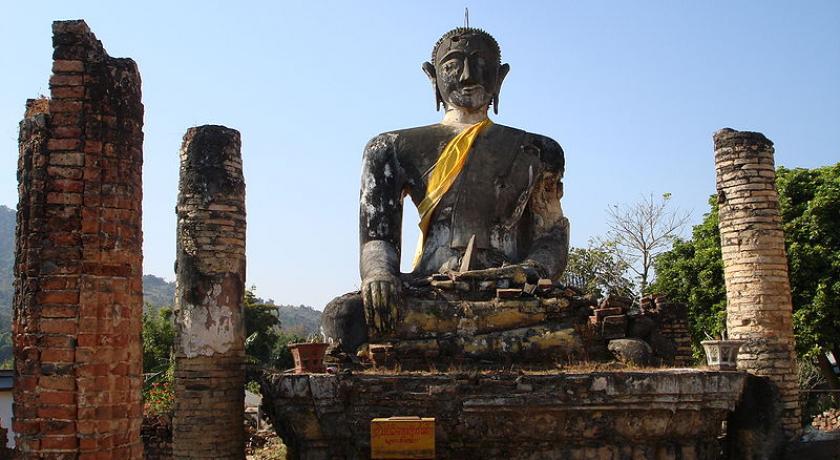
Muang Khoun is the 14th century ancient Phuan Kingdom capital. It is accessed southeast of Phonsavanh. Destroyed in the Indochina War, ruins of a stone wall with brick archways, relics of France's colonial rule, a large size Buddha, pillars and short wall sections of Wat Piawat temple (built in 1564) are visible. Once buried in the forest, the 450-year-old That Foun Stupa is visible near the road outside Phonsavanh. In the ethnic Phuan village, located to the south of Phonsavanh, Ban Napi mounds war scraps are seen buried in tableware. During the 1980s creative thinking resulted in eight families putting together aluminum bits of damaged aircraft in mounds of melted lack, wood and ash to supplement their income. Such war debris is found scattered between Lang Waterfall and Jar Site 3.
A secret tunnel was constructed below the hills of the Phu Kheng Jar Quarry Site during the Indochina War (1964–1973). The tunnel is approached by climbing about 1,000 steps. Along this route many bomb craters and broken or incomplete jars are found. The views of the Phoukoud valley at the end of the route are very scenic, and the entry to tunnel is not readily seen. The tunnel is 70 metres (230 ft) in length and 1.6 metres (5 ft 3 in) high. Reinforced concrete bunkers with night camps are also seen along this route. UXOs (unexploded ordnance) found in very large numbers in the province are in the process of getting cleared under aegis of the UK-based Mines Advisory Group (MAG). The Visitor Information Centre established by (MAG) in Phonsavanh provides information on the history of the bombing campaign particularly of the cluster bombs and the destruction they caused during the war; are explained through sketches and a documentary film. It is said that the bombing of the province was a record of a kind as "the most densely bombed area per capita on earth".
Caves - refuges for thousands of people
During the war thousands of local residents took shelter in caves and set up hospitals and schools; the army used the caves as well to store weapons and medical supplies. Two major caves are open to the public:
Tham Piu Cave is located 6 km north of Muang Kham. In one of the many tragedies of the so-called Secret War on 24 November 1969, a single rocket fired from a US aircraft killed an estimated 374 people, rumoured to be an entire village, who had taken refuge in the cave. Their bones are still buried in the rubble. The cave is far away from Phonsavan but it's an amazing drive through pine forests, mountains, fields and past the many villages along the route. The journey to the cave also allows for stopovers at other points of interest, including Baan Ki, Baan Tachok, and Baan Nathong & Tai Dam/Khom crafts provided you leave no later than 09:00. Directions: From Phonsavan head NW along route 7 for about 55km until you reach Bang Sa and turn left just after the Western Union next to the Post Office. Drive past the signposted road to the Plain of Jars (50 km) on your left hand side, over the bridge and past the small cemetery on the left for about 5 km until you reach the sign to the cave for then turn left. From here the road becomes extremely cracked and uneven. After short drive (about 3 km) through a small village you will arrive at the Tham Piu entrance. Route 5 will also lead you there (signposted on route 7 but after the post office/Western Union) however, the way is not direct and nor signposted after the initial left turn so you will have to ask for directions or make educated guesses. The entrance fee is 5,000 kip. The caretakers are friendly and if they're not busy then they are more than happy to show visitors around the grounds which contain statues, shrines and even a small museum. They will even open up the shrine if it is locked away and conduct prayers if you purchase incense and candles. To reach the caves walk past the shrine/museum and follow the winding concrete steps past the Buddha and aqueduct for about 5 minutes to the mouth of the cave. Small piles of rocks with incense and offerings are there to honour the dead and there is also a simple shrine at the entrance.
Tham Xang Caves are located in a scenic karst area, the caves were used by the revolutionary fighters. Inside the cave complex they set up a hospital, an arsenal and a medicine depot. Evidence can still be seen. Besides its war history the illuminated residential cave is worth visiting to see its natural beauty. The Hmong community of Ban Ta takes care of the caves and offers a local tour guide service. Directions: The caves are 36km northwest of Phonsavanh. Take Route 7, pass Nong Pet, then in Nam Ka village turn left into a dirt road; follow the signs to Tham Xang until you reach Ban Ta. The drive to Tham Xan is very scenic and possibly one of the best in the area. You’ll drive pass thatched huts, large open fields and into the mountains. The booth to the cave is sporadically manned, as is the toll booth. As of November 2012 the medical depot was left open but the munitions cave was locked.
Scenery & nature
Xieng Khouang is widely known for the Plain of Jars, but beyond its jars the natural beauty of the province is waiting to be discovered. Xieng Khouang’s scenery is characterised by the highest mountains in the country (Mount Phou Bia), its pine forests, deciduous woodlands, rolling hills and grasslands. In the cold season the green hills of the Plain of Jars turn reddish brown giving it a touch of the “Wild West” with yellow sunflowers and pointsetta in full bloom. Nam Ngum, the largest river in the province originates from the mountains in Paek District and is one of the major tributaries of the Mekong. Nong Het and Phaxay District in particular offer stunning karst scenery with plenty of caves, cliffs, underground rivers and waterfalls. Visiting the area is very beautiful during peach and orchid tree blossom in February.
Nong Tang Lake. Nong Tang is a large picturesque natural lake flanked by high limestone cliffs. Locals use it for fishing and it is a favourite picnic site. Enjoy the peaceful setting in the local restaurant. Overnight stay is available in a guesthouse along the shore. Nongtang is located 48 km from Phonsavanh on Route 7 going to Phou Khoun.
Hot Springs can be visited in the vicinity of Muang Kham off Route 7. The big hot spring Baw Nyai is 67 km from Phonsavanh, has been developed as a resort with bungalows and indoor bathing facilities. You can walk through the forest to the spring source, but swimming in the pool is not possible. The Jar Site of Ban Nam Hom is just a 2 km walk away. This jar site offers an insight in how the jars were made as part of the jar site is a jar quarry area. Taking a guide to visit the site is recommended.
Tad Ka Waterfall in Nong Het. This impressive waterfall is surrounded by spectacular limestone karsts. The water runs down in cascading steps alternating with steep areas for more than 100 metres and flows all year round. To get to the falls follow Route 7 to Nong Het, at Khang Phaniane Village turn left into a graveled road (100 km from Phonsavanh) and drive for about 3 km; take the trail to the left and walk about 30 minutes to get to the waterfall. Taking a guide is recommended.
Tad Ka Waterfall in Tajok. The waterfall is located near Tajok village, 32 km north of Phonsavanh. The water flows over several tiers. A spectacular jungle trail winds its way up the waterfall crossing it several times. Tad Kha is a popular picnic spot for locals, especially during the Lao New Year holidays. To get there turn right at the end of Tajok village; follow the road until you see a building to the right. Walk along the ridge and take the right trail down. Local tour companies offer day tours including a picnic lunch and a hike up the waterfall.
Tad Lang Waterfall. Tad Lang is located near Jar site 3 just 700 metres off the road to Ban Nakang cascading down ca. 800 metres. To enjoy its whole beauty follow the trail down to the bottom of the valley. It is a good picnic spot, but because you must cross a river to reach it, access is difficult in the rainy season.
Thathom. Travelling to Thathom, located 130 km south of Phonsavanh, is still an adventure. Driving mainly on dirt roads you pass thick deciduous forests, stands of bamboo, remote villages and cross rivers several times. Thathom offers a gorgeous karst landscape with plenty of rivers, caves and historical sites, but so far, tourist services are scarce. Song thaews (pick-up trucks) leave Phonsavanh daily, but there are no regular trips in the rainy season. Boat services are available once you reach the Nam Xan River going to Paksan in Bolikhamxay province.
Do
The SOS orphanage in Xieng Khouang was founded 1998 to take care of the many children who lost their parents in accidents related to UXO. Today 145 children live in 12 family houses. The associated kindergarten and primary school are open to local children. You are welcome to visit the centre during office hours Mon - Fri from 8:00-16:00, Check in at the administration building first.
The local fresh food market is an excellent place to sample the variety of unique foods that Xieng Khouang has to offer. The cool climate and high altitude of the province produces many food items and forest products that are not available in other parts of Laos, e.g. mushrooms, peaches, plums and passion fruit. Some people also sell exotic meats, such as living bamboo rats or pheasants. Please remember to support wildlife conservation and do not eat endangered species.
The Navang Craft Centre is famous for woodcarving. This family business produces wood crafts made from scented Long Leng Wood (Fujian Cypress), a rare wood. You can watch the carvers work and buy souvenirs daily from 7:30-20:00.
There is a Hmong Crafts Centre in the city centre offering products made by Hmong. In the same shop is also a Thai massage parlor run by a group of 4 experienced Thais. The boss is training locals in masssage.
There are several War Memorials in Phonsavanh that were constructed to commemorate the thousands of Pathet Lao soldiers who lost their lives during the Indochina Wars and to honour the Vietnamese soldiers who fought alongside them. Climb up the small hills and you will be rewarded with great views of the town and surrounding areas.
The Mulberry Silk Farm of Lao Sericulture Co, a fair trade company, is dedicated to enabling Lao village silk producers in the Northern provinces to revive the art of high quality local silk production. Villagers are trained in sericulture, the process of raising silkworms, processing and improved weaving techniques and natural dying. Leaves, bark, vines, berries and seeds create colour choices to match virtually any taste. To learn about the whole process you are welcome to visit the farm. A free guided tour which takes about 30 minutes leads you through the production process. Any purchase of souvenirs will help the local communities and enabling them to rise out of poverty. It is located in Ban Li (just west of Phonsavan on Route 7) and is open Mon - Sat 08:00 - 16:00.
MAG Office-UXO Visitor Information Centre in the centre of Phonsavanh (opposite Craters restaurant) the Mines Advisory Group (MAG) informs about the UXO (unexploded ordnance) problematic in the province. MAG began its Lao program in 1994 and started the first internationally supported UXO clearance operation in Xieng Khouang. MAG works to help people to rebuild their lives and alleviates suffering by responding to the needs of conflict affected communities. Local staff has been training to clear away the brush, to use a metal detector and recognize ordnance. Their village assisted clearance approach allows communities to participate in the process. Open Mon - Fri 08:00-20:00 and Sat/Sun 16:00-20:00. Documentaries are screened daily (16:30/17:50-18:30-'Bombies') free of charge. Visiting local UXO clearance sites can also be arranged but only if you have obtained permission from the Veng Vieng office. Visiting the centre is free but donations are appreciated. T-shirts are available for $10.
UXO Survivor Information Centre is in the main street of Phonsavan, two doors along from MAG. The Centre is operated by the Quality of Life Association (QLA) which is a provincial not for profit organisation that provides support for UXO survivors. They cover the cost of initial and ongoing medical treatment of UXO survivors and manage a range of livelihood training initiatives to help them to have a sustainable livelihood after their accident. A common cause of UXO accidents is digging on the farm, so for many UXO victims, farming is no longer an option. The organisation is also about Lao people helping Lao people; the QLA team and also their Board of Directors are Lao nationals, some of whom are UXO survivors themselves. The Centre has an exhibition with information about the various programs and short stories about some of the people they have helped. The Centre also includes a small shop comprising handicrafts that have been made by UXO survivors and UXO affected communities. The proceeds go to UXO survivors and towards buying more materials for making more products. Well worth a visit. Open all week, Mon & Tues until 4pm, Wed to Sun until 8pm.
Old Cemetery and Lake Jao Supanouvong. This large cemetery is located on a hill 1 km north of Phonsavanh. What makes it unique is that Tai Dam animist tombs are mixed together with Catholic tombstones, Chinese graves and Lao Buddhist reliquary. The hill top offers sweeping views and is an ideal spot for watching the sun set of the green hills. The lake 3km north of town is named in honour of Prince Supanouvong the first president of the Lao PDR. Once the site of the provincial jail, it is now a place for relaxation.
Participate in English classes at Phonsavan school (English Centre, Phonsavan school). English speaking tourists are welcome to participate in English evening classes in the local primary - junior high school. It is a beautiful experience, and you don't have to be a teacher! My friend had seen a sign in the Craters Cafe. The lovely staff transfered us to and from the school, which is not far from the bus terminal.
Nathong Cultural Village from Phonsavan head NW along route 7 (towards the Tham Piu caves) for about 45 km and turn right at blue the sign in Laos/English for about 1 km until the gravel road forks out. The village itself is nothing special and pretty much the same as any of the others you'll pass, however, the locals are extremely friendly and will burst into laughter when you ask to take their picture!
Muang Nam from Phonsavan head NW along route 7 for about 40 km on the way towards the Tham Piu Cave. There is little of interest here aside from the view from the Kham bridge, the house just past the bridge surrounded with UXO and the friendly locals.
Culture
Typical local products from Phonsavanh and the surrounding area are natural dyes and textiles each with individual pattern depending on the ethnic group, basketry, mulberry paper umbrellas, spoons made from war scrap or Hmong embroidery. A special drink is Matsutake Whiskey made from Hed Wai, a highly valued mushroom from the pine forests of Xieng Khouang.
Get in
Phonsavan's Xiang Khouang Airport (IATA: XKH) fields 4 flights per week to Vientiane.
Lao Airlines offers six flights a week in peak season and four flights in low season. Coming from Vinh or Hanoi in Vietnam, visas are available on arrival at the Nam Ka border, which is open daily from 6:00 – 18:00. The bus from Vinh leaves four days a week and takes 12 hours, from Hanoi there is one bus per week.
If you are travelling from Vientiane you can either take VIP buses or local buses. The buses leave from the northern bus terminal and take about 10-12 hours. Note: The roads are paved but there are plenty of serpentines. The bus trip from Vang Vieng takes 7-8 hours. Buses run daily from Luang Prabang via Route 13 and 7 and take 8 hours. Shared minivan options to the most popular destinations (Luang Prabang, Vang Vieng and Vientiane) are now offered by travel agencies. There is a regular VIP bus from Paksan bus terminal (inside the market) at 7:30 to Phonsavan that takes 7-8 hours.
As of early 2011, there were two buses running daily from Vinh in Vietnam, going from the main bus station at 6:00am (no reservations necessary). Vinh can be easily reached by train from Hanoi or Ho-Chi-Minh-City.
Get around
To get to other towns in the province you can take local buses or pick-up trucks. Inside Phonsavan, there are plenty of tuk-tuks, which might not be available without prior booking very early in the morning or late at night. A normal tour inside the town should cost about 10 000 kip. There are 9 travel agents in Phonsavan that arrange bike, motorbike and car rentals. A bike costs depending on quality from 20 000 Kip per day. You can rent mostly scooters for about 100 000 kip from a tout or 70,000 kip from an agency along route 7. Mr Vhong of Sabaidee Xiengkhouang Travel Services (open 08:30-21:30) next to Nice Guest house opposite Nisha Restaurant is an easy going and amiable man who speaks good English. He rents motorbikes for 70,000 kip per day, and can also arrange a guide for 80,000-100,000 kip per day. To rent a minivan costs about $50-80 US, but a four-wheel drive costs over $100 US. This includes or excludes fuel, depending on the company. All prices vary hugely depending on season and availability.
Note that tuk-tuks are not allowed to take tourists to the Jar sites. You can visit the site with a certified guide or individually.
Stay safe
There's been a recent surge in motorcycle accidents due to poor brakes and equipment. Ensure the fundamentals are in good working order before taking it out any further.
Phonsavan is now well catered for tourists and foreigners, with many tourist offices lining the main street.
Warning - Phonsavan is one of the most heavily bombed places in the world. There are unexploded ordinances everywhere, and on average 60 people die each year due to UXOs. Take extreme caution when wandering around any off-the-beaten paths. Stay on the paths unless it is absolutely necessary to do otherwise.
Buy
Typical local products from Phonsavanh and the surrounding area are natural dyes and textiles each with individual pattern depending on the ethnic group, basketry, mulberry paper umbrellas from Ban Mixay, spoons made from war scrap from Ban Napia or Hmong embroidery. A special drink is Matsutake Whiskey made from Hed Wai (known in Japan as matsutake), a highly valued mushroom from the pine forests of Xieng Khouang. Finely woven silk scarves and textiles can be purchased from the UXO Survivors Centre, Mulberry Farm and Khom Districts Craft Centre.
Recycled UXO bracelets, bottle openers and the collectible spoons can be purchased for 20,000 kip each from the Khom Districts Crafts Centre far from town. The spoons can easily be bulk purchased cheaply from the local market on the road parallel to route 7 behind Nice guest house. However, should you wish to purchase the spoons, bracelets or bottle openers from the source and therefore directly benefit the villagers who make them you will have to hire a bike and go Ban Napia yourself or hire a private guide.
Eat
Phonsavanh has a surprisingly broad offer of food for a provincial town its size. There over 30 restaurants and many Pho soup shops. You can easily find Chinese, Vietnamese and Lao restaurants but also a good choice of European food. The restaurants are the natural place for a drink.
Sleep
There are 12 hotels and 39 guest houses in Phonsavan. Most guesthouses are located on and around the main street - travel books normally recommend Nice Guest House, White Orchid or Dok Khoun Guesthouse (there is a hotel of the same name).
For general information visit the Provincial Tourism Department near the market, Thalat Nam Ngum, on the road to the airport. xkgtourism@yahoo.com.
Source https://en.wikipedia.org/wiki/Xiangkhouang_Province
http://wikitravel.org/en/Phonsavan
Address
Xiengkhouang Province
Laos
Lat: 19.609300613 - Lng: 103.728919983

